This article has multiple issues. Please help improve it or discuss these issues on the talk page. (Learn how and when to remove these template messages)
|
Shillya also spelled as Shilla or Silla is a village located in Lowa Ramgopalpur Gram Payanchayet in Galsi I CD Block in Bardhaman Sadar North subdivision of Purba Bardhaman district in West Bengal in India.
Shillya | |
|---|---|
Village | |
 Shillya Location in West Bengal, India  Shillya Shillya (India) | |
| Coordinates: 23°17′37″N 87°34′23″E / 23.29361°N 87.57306°E | |
| Country | |
| State | West Bengal |
| District | Purba Bardhaman |
| Population (2011) | |
| • Total | 1,272 |
| Languages | |
| • Official | Bengali, English |
| Time zone | UTC+5:30 (IST) |
| Lok Sabha constituency | Bardhaman-Durgapur |
| Vidhan Sabha constituency | Galsi |
| Website | bardhaman |
Geography
editShillya village is located at 23.2937 N 87.572952 E, on the bank of Damodar River. It is under Galsi (Vidhan Sabha constituency).
Climate
editThe Köppen Climate Classification sub-type for this climate is "Aw" (Tropical Savanna Climate).
| Climate data for Shillya, Burdwan, India | |||||||||||||
|---|---|---|---|---|---|---|---|---|---|---|---|---|---|
| Month | Jan | Feb | Mar | Apr | May | Jun | Jul | Aug | Sep | Oct | Nov | Dec | Year |
| Mean daily maximum °C (°F) | 26.0 (78.8) |
27.5 (81.5) |
34.5 (94.1) |
37.4 (99.4) |
32.6 (90.7) |
34.9 (94.9) |
32 (90) |
32.3 (90.1) |
32.4 (90.3) |
32.0 (89.6) |
28.0 (82.4) |
26.0 (78.8) |
31.32 (88.38) |
| Mean daily minimum °C (°F) | 12.0 (53.6) |
15 (59) |
20 (68) |
24.9 (76.8) |
25.9 (78.6) |
26.0 (78.8) |
25 (77) |
25 (77) |
25 (77) |
24.7 (76.5) |
17.5 (63.5) |
12.5 (54.5) |
21 (70) |
| Average precipitation mm (inches) | 18 (0.7) |
38 (1.5) |
33 (1.3) |
48 (1.9) |
130 (5) |
240 (9.6) |
350 (13.7) |
310 (12.3) |
290 (11.4) |
160 (6.2) |
28 (1.1) |
5.1 (0.2) |
140 (5.4) |
| Average rainy days | 4 | 3 | 4 | 6 | 10 | 18 | 23 | 22 | 18 | 11 | 3 | 1 | 123 |
| Source: Weather2[1] | |||||||||||||
Population
edit| Data | Total people | SC | ST |
|---|---|---|---|
| Male: | 646 | 259 | 2 |
| Female: | 626 | 262 | 2 |
| Total: | 1272 | 521 | 4 |
| Header text | Sex Ratio | Literacy |
|---|---|---|
| Shillya | 969 | 78.55% |
| West Bengal | 950 | 76.26% |
There are 285 families and total population of the village is 1272. Among them 646 are males and 626 are females. There are 521 Scheduled Caste (259 males and 262 females) and 4 Scheduled Tribe (2 males and 2 females). The average sex ratio of this village is 969 which is greater than West Bengal average of 950. Literary rate of this village is 78.55% (male 83.39% and female 73.49%) which is also greater than West Bengal literacy which is 76.26%. Here 40.96% of people are from Scheduled Caste and 0.31% people are from Scheduled Tribe. [2]
Neighbourhoods
editThe village Shilla has neighbourhoods or paras.
Upper Shillya
editIt is known as Upper Shillya as this part has higher ground level than other parts of Shilla.
Namo Shillya
editIt is known as Namo Shilla (Namo means lower) because this part is lower than the other parts of Shilla.
Shillya ghat
editIt is known as Shillaghat/Shillyaghat (ghat means collecting centre of sand or bank of river) as it is the sand collecting spot.
Culture
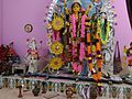
editThere are two temples of the Hindu goddess Durga at Upper Shilla. There are also three temples of Devi Kali and two temples of Devi Manasa at Upper Shilla. There is another temple of Durga at Namo Shilla. A small fair is organized here in the winter season (on the last day of the Bengali month Poush) beside the Damodar River.
Gallery
edit-
 Sunset at Shillya
 -
 Evening at Shillya
 -
 Damodar River at Shillya
 -
 Shillya mission temple
 -
 Durga of Shillya
 -
 Durga Murti
 -
 Upar Shillya Durgatala


References
edit- ^ "weather2.com". Weather2. 2013. Retrieved on 6 October 2013.
- ^ View Census Report